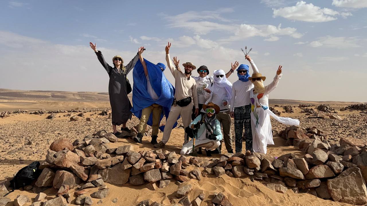
The temperature is +45°C, sand is everywhere — yet the explorer’s drive never fades.
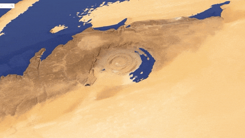
The team of the Laboratory of Alternative History has completed its fifth field expedition to Mauritania — to the Richat Structure, known as the “Eye of the Sahara.”
This site has remained at the center of research, discussions, and expeditions for several years.
During this time, Dmitry Pavlov and the LAI team have gathered and systematized more than twenty-five correspondences between Plato’s description of Atlantis and the real geography of the Adrar Plateau in Mauritania.
These parallels are not based on speculation — each one is supported by direct observations, measurements, and satellite data: from the precise proportions and orientation of the concentric rings to the channels, water sources, rock colors, and traces of Atlantis’s ancient hydraulic system.

21°06’18″N 11°25’28″W
During the fifth expedition, our team explored new areas where straight channels and traces of powerful water flows were recorded.
One of these channels, about nine kilometers long, precisely matches the dimensions of the main canal of Atlantis’s capital, as described by Plato.

A detailed report on the research results will be released soon.

21°31’58″N 10°35’18″W
In the meantime, let’s take a closer look at what Dmitry Pavlov and the LAI team have managed to gather — and which correspondences have already been confirmed in practice:

📜 Comparison with the Original Source:
Below are 21 correspondences between Plato’s description of Atlantis in the dialogues Timaeus and Critias and the Richat Structure in Mauritania, explored by Dmitry Pavlov’s expeditions.
1️⃣ Rings of land and water
Plato (Critias, 115e–116a):
“Poseidon made alternate rings of sea and land around the hill — two of land and three of water, perfectly regular in form, as if turned on a lathe, and at equal distances from one another.”
✅ Match: The Richat Structure is a system of concentric rings. Its geometry corresponds precisely to Plato’s description.

2️⃣ Size of the Central Island
Plato (Critias, 116a–b):
“The island in which the royal palace stood had a diameter of five stadia.
The ring of water surrounding it was of the same width as the island itself;
the next ring of land was also five stadia in width;
then another ring of sea of equal breadth;
and finally two more rings — one of land and one of sea — each three stadia wide.
Thus, the distance from the outermost sea to the center of the island, where the palace stood, amounted to fifty stadia.”
✅ Match: Fifty stadia correspond to roughly 9 kilometers from the center to the outer sea — about 18 kilometers in total diameter for the capital, including its rings of land and water.
Considering thousands of years of erosion and variations in the ancient Greek measure of the stadion (157–211 meters), the discrepancy remains within an acceptable margin of error.
💠 Additional Note: On modern maps, the Richat Structure displays six concentric belts, whereas Plato described five.
This can be explained by the fact that the outermost ring likely formed much later — after the catastrophe and subsequent desertification, when erosion removed upper sediment layers and exposed deeper strata of the ancient dome.
In the age of Atlantis, these outer rings may have been buried beneath soil, vegetation, and water bodies, and therefore not perceived as a separate belt.
Erosion and the desertification of the Sahara eventually revealed the entire structure, making it visible as we see it today — in the form of the concentric rings of the “Eye of the Sahara.”

Right caption: Now
3️⃣ North and South
Plato (Critias, 118a):
“The whole region was very lofty and precipitous toward the sea… The northern side was sheltered by mountains, while the southern part faced the sea and was protected from the northern winds.”
✅ Match: The Richat Structure lies on the Adrar Plateau. To the north rise mountain ridges, while to the south the terrain descends toward the ancient seabed — exactly as Plato described.равнина, спускающаяся к древнему морю (ныне пустыня).
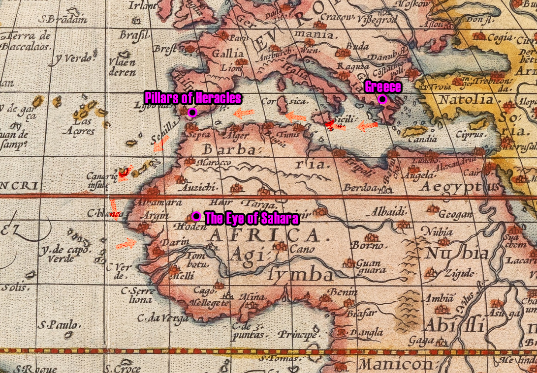
4️⃣ Location “Beyond the Pillars of Heracles”
Plato (Timaeus, 24e):
“At that time it was still possible to cross this sea, for in front of the mouth which you Greeks call the Pillars of Heracles there lay an island.”
✅ Match: Mauritania is indeed located west of the Strait of Gibraltar — that is, “beyond the Pillars” from the Greek perspective.
5️⃣ Straight Canals
Plato (Critias, 118d–119a):
“The whole plain was intersected by straight canals, running across it and toward the city… Each canal was a hundred feet in breadth, and they were set at intervals of one hundred stadia.”
✅ Match: Numerous straight channels are visible today in satellite imagery. The longest of them — known as “Plato’s Canal” — stretches for about 100 kilometers.

19°39’33″N 12°31’20″W
6️⃣ Moisture and Oases
Plato (Critias, 117a–b):
“Around the temple and the palace there was land which was exceedingly fertile and richly watered.”
✅ Match: Around the Richat Structure stretches a network of ancient riverbeds and oases — traces of a once lush, irrigated plain.
Even today, during the rainy season, more than a thousand temporary rivers and streams descend from the Adrar Plateau, bringing life to the valleys surrounding the structure. This demonstrates that Richat lies at the center of an ancient watershed system, confirming that this region was once a water-rich heart of the green Sahara.

7️⃣ The Flood and the Catastrophe
Plato (Timaeus, 25c–d):
“Afterwards, in a single dreadful day and night… the island of Atlantis disappeared, being swallowed by the sea.”
✅ Match: The chronology — around 12,000 years ago — corresponds to the end of the last Ice Age, a period marked by massive floods and climatic cataclysms.

8️⃣ Silt at the Ocean Entrance
Plato (Timaeus, 25d):
“The sea in those parts has become impassable and unnavigable, because there is a shoal of mud in the way; and this was caused by the subsidence of the island.”
✅ Match: The ancient Tamanrasset River, which once flowed into the Atlantic Ocean, may have been blocked by massive silt deposits formed after the catastrophe.

9️⃣ Colors of the Rocks
Plato (Critias, 116a–b):
“They quarried stone of white, black, and red colors from beneath the island.”
✅ Match: In the Richat Structure, rocks of exactly these three colors — white, black, and red — are found.

🔟 Elephants
Plato (Critias, 115a):
“There were a great number of elephants upon the island.”
✅ Match: During the Late Pleistocene (up to 12,000 years ago), elephants inhabited Western Sahara, including the Adrar Plateau.
Ancient rock carvings and old maps depicting rivers and animals in this region confirm their former presence.

The iron content in its rock reaches about 70%, and the site is still actively mined today.
1️⃣1️⃣ Neighboring Continent
Plato (Timaeus, 25a):
“From this island one could easily pass to the other islands, and from them to the opposite continent which surrounds that sea.”
✅ Match: If Atlantis was part of North Africa, the condition is fulfilled — the continent lies right nearby.

Below is a climate curve showing the warming and drying phases over the past 23,000 years.
1️⃣2️⃣ Fertile Valley
Plato (Critias, 118a–b):
“This plain faced toward the south and was sheltered from the north by mountains… From them flowed rivers that fed lakes and meadows… there were vast forests providing wood in great abundance of every kind.”
✅ Match: The Richat Structure faces south and is bordered to the north by the Adrar Massif — the very direction from which seasonal rivers still descend today.
In the ancient riverbeds surrounding the structure, traces of silt and black soil have been found — remnants of the fertile valley described by Plato.

1️⃣3️⃣ Canals and Navigable Passages
Plato (Critias, 115d):
“They dug a canal from the sea which was three plethra in breadth, one hundred feet in depth, and fifty stadia in length, reaching as far as the outermost ring of water.”
✅ Match: During the most recent LAI expedition, a new main canal was discovered that matches Plato’s description in both orientation and scale.
This finding reinforces the hypothesis that an ancient hydraulic system once existed in the Richat area, remarkably consistent with Plato’s account of Atlantis.

21°03’57″N 11°23’11″W
1️⃣4️⃣ Geometry of the Plateau
Plato (Critias, 118a):
“The whole region was elevated and precipitous toward the sea, and all around lay a level plain.”
✅ Match: The Richat Structure stands on a high plateau, surrounded by a flat plain that gradually descends into the ancient seabed.

1️⃣5️⃣ Agriculture and Fertility
Plato (Critias, 118e–119b):
“Owing to the multitude of canals, the water which flowed down from the mountains made the land rich with moisture, yielding crops twice a year — the winter crop from the rains and the summer crop from the irrigation channels.”
✅ Match: In ancient times, the region surrounding the Richat Structure was part of the Green Sahara — a vast, fertile plain filled with rivers, lakes, and forests along the slopes of the Adrar Plateau.
Sediment samples reveal thick layers of black soil and silt, traces of former fields and meadows.
On the mountain plateaus, ancient riverbeds remain visible, and pollen found in deposits confirms the presence of rich vegetation — acacias, palms, grasses, and cereals.
This fully aligns with Plato’s description of Atlantis as a land “abundant in moisture and so fertile that it yielded crops twice each year.”

1️⃣6️⃣ Hot and Cold Springs
Plato (Critias, 117b):
“Poseidon caused two springs to flow from the earth — one of warm water and the other of cold.”
✅ Match: During the first LAI expeditions in the Richat area, researchers recorded radon gas emissions rising from deep fissures in the central part of the structure.
This indicates residual geothermal activity — possible remnants of the underground flows that, in ancient times, could have fed the “two springs — one warm and one cold” described by Plato.

1️⃣7️⃣ Orichalcum and Minerals
Plato (Critias, 114e–115a):
“The land contained many metals, among them orichalcum, which was dug out of the earth and was then only inferior in value to gold.”
✅ Match: In the vicinity of the Richat Structure and across the Adrar Plateau, there are iron-rich rock formations of exceptional purity.
Even today, the region hosts active mining operations, with iron content reaching up to 70% in some local deposits — among the highest concentrations on the continent.
This abundance of minerals strikingly echoes Plato’s description of Atlantis as a land “rich in metals and shining with orichalcum.”

1️⃣8️⃣ Connection with Egypt
Plato (Timaeus, 21e–23d):
“These accounts are written here in Sais, where the records of the most ancient times are kept; they were related to Solon by a priest well versed in these traditions.”
✅ Match and Cultural Continuity:
According to Plato, it was the Egyptian priests of Sais who told Solon the story of Atlantis.
Modern findings and visual observations further reinforce this link: small artifacts bearing the Eye of Horus, the ancient Egyptian symbol of protection and wisdom, have been found in the region.
When the ancient world is viewed in the Egyptian map orientation — with south at the top — the mountain relief of the Adrar Plateau itself resembles the same symbol, pointing to a possible shared sacred geometry or cultural echo between Egypt and Atlantis.жную культурную преемственность между народами Западной Сахары и Египта.

Thus, the memory of the Atlanteans may have been preserved in Egyptian myths — in the image of the Eye of Horus, a symbol of restoration, knowledge, and all-seeing awareness.
Andrey Sklyarov proposed a hypothesis that Egypt could have been one of Atlantis’s colonies, and that Egyptian civilization was the direct heir to its knowledge and spiritual tradition.

1️⃣9️⃣ Lakes and Water Bodies
Plato (Critias, 118b):
“There were many lakes, supplied by rivers and by rainfall.”
✅ Match: Traces of ancient lakes, seas, and river systems surround the Richat Structure, including a large dried-up lake on the Adrar Plateau, which is still remembered by local inhabitants and clearly visible in satellite imagery.

2️⃣0️⃣ Submarine Landslides and Traces of the Catastrophe
Plato (Timaeus, 25d):
“The island of Atlantis disappeared in the sea in a single day and night of misfortune…”
✅ Geological Connection:
On the Atlantic seafloor off the Mauritanian coast, scientists have identified massive underwater landslides and sediment plumes dated to around 12,000 years ago.
These formations may be the geological trace of the very catastrophe described by Plato.
The upcoming LAI maritime expedition is headed to this region to study the continental shelf structure and investigate the origin of these formations.

2️⃣1️⃣ Epoch — 12,000 Years Ago
Plato (Timaeus, 23e):
“Nine thousand years before the time of Solon.”
✅ Match:
Solon lived around 600 BCE, placing the described events at roughly 11,600 years ago — precisely the period of an abrupt climatic shift marking the end of the Ice Age and the beginning of the Holocene, confirmed by Greenland ice cores and ocean sediment records.
Thus, both the timing and the nature of the events correspond closely to Plato’s account of Atlantis’s destruction.

2️⃣2️⃣ Overall Probability
✅ Conclusion by Dmitry Pavlov:
With more than twenty direct correspondences between Plato’s description of Atlantis and the actual parameters of the Richat Structure, the probability of a random coincidence tends toward zero.
Such a number of precise matches goes beyond the limits of statistical error and indicates a systemic correlation between the ancient text and the real geographical object.
The only thing left is to find the Atlanteans.

We continue the search.
Everyone can become part of this story — to travel with us to Mauritania, see the Richat Structure, and perhaps make a discovery of their own.

From myself:
Thank you to everyone who is with us — those who have been here from the very beginning, and those who have joined us along the way. 🙏
Two years ago, I saw Dmitry Pavlov’s story about the Richat Structure and set out on my first journey with LAI.
Since then, I’ve returned from the Sahara three times, visited Egypt, Lake Baikal, and the dolmens of the Caucasus.
These expeditions have changed much — my outlook, my sense of time, and my understanding of history.
Now I continue this path: sharing discoveries, and telling the stories of what we see and feel during our expeditions.
The journey has only just begun.
Laboratory of Alternative History © November 5, 2025
Telegram Support: @AtlantGGbot